 |
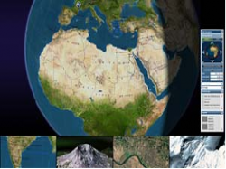
Mirror Worlds are reflections of the real world (such as landscapes, cities, etc.), in which a user can move freely. The necessary geospatial information comes from pictures taken from outer space (satellite images) as well as from aerial photographs. This image data is superimposed on 3D digital elevation models (DEMs) in various resolution up to street level. This allows the visualisation of city models and buildings with walk through functionality. Google has prepared this market and has developed the first professional application (Google Earth). Therefore more and more end-users (consumers) require comparable 3D solutions.
With the software for Mirror Worlds, we enable our customers to transform their existing geospatial data into new online business models. The quality depends essentially on the availability of satellite imagery or aerial photographs. Large amounts of data even complete city models and landscapes can be visualized on the Internet using intelligent data streaming. The user interface of the software product and features such as access rights or the necessary level of encryption can be determined from the business models of our customers.
With the geospatial viewer software BS Contact Geo we support a variety of applications from navigation solutions to tourism portals.